Out-of-the-box, Dundas BI offers a wide array of geo maps at different levels. For example, world maps grouped at the continent of country level, specific countries grouped at the state or province level, countries grouped at the city level and so on.
But in some cases, one may want to create custom geo groups that are not necessarily common geo groups, but instead are groups defined to align with internal operations.
To visualize those custom groups, one may use esri map shape files dedicated editors such as QGIS in order to create maps with predefined shapes representing those groups. Or instead, one may use the Shape Compatible Name property in order to align that shape to be part of the designated group.
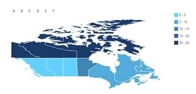
For example, if I wanted to show a map of Canada grouped by regions A to F using the following data structure:
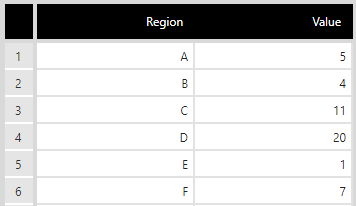
I could assign the different provinces I want to associate with the different regions the relevant shape compatible name (e.g. all Maritime provinces belong to Region A), and then simply bind my data like I would normally do to my mapand get the following map: